Near the Horseshoe - geograph.org.uk - 1460792
Description:
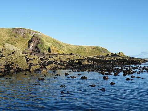
Summary.mw-parser-output table.commons-file-information-table,.mw-parser-output.fileinfotpl-type-information{border:1px solid #a2a9b1;background-color:#f8f9fa;padding:5px;font-size:95%;border-spacing:2px;box-sizing:border-box;margin:0;width:100%}.mw-parser-output table.commons-file-information-table>tbody>tr,.mw-parser-output.fileinfotpl-type-information>tbody>tr{vertical-align:top}.mw-parser-output table.commons-file-information-table>tbody>tr>td,.mw-parser-output table.commons-file-information-table>tbody>tr>th,.mw-parser-output.fileinfotpl-type-information>tbody>tr>td,.mw-parser-output.fileinfotpl-type-information>tbody>tr>th{padding:4px}.mw-parser-output.fileinfo-paramfield{background:#ccf;text-align:right;padding-right:0.4em;width:15%;font-weight:bold}.mw-parser-output.commons-file-information-table+table.commons-file-information-table,.mw-parser-output.commons-file-information-table+div.commons-file-information-table>table{border-top:0;padding-top:0;margin-top:-8px}@media only screen and (max-width:719px){.mw-parser-output table.commons-file-information-table,.mw-parser-output.commons-file-information-table.fileinfotpl-type-information{border-spacing:0;padding:0;word-break:break-word;width:100%!important}.mw-parser-output.commons-file-information-table>tbody,.mw-parser-output.fileinfotpl-type-information>tbody{display:block}.mw-parser-output.commons-file-information-table>tbody>tr>td,.mw-parser-output.commons-file-information-table>tbody>tr>th,.mw-parser-output.fileinfotpl-type-information>tbody>tr>td,.mw-parser-output.fileinfotpl-type-information>tbody>tr>th{padding:0.2em 0.4em;text-align:left;text-align:start}.mw-parser-output.commons-file-information-table>tbody>tr,.mw-parser-output.fileinfotpl-type-information>tbody>tr{display:flex;flex-direction:column}.mw-parser-output.commons-file-information-table+table.commons-file-information-table,.mw-parser-output.commons-file-information-table+div.commons-file-information-table>table{margin-top:-1px}.mw-parser-output.fileinfo-paramfield{box-sizing:border-box;flex:1 0 100%;width:100%}} Description: English: Near the Horseshoe The Horseshoe is the name given to one of the rocks on this stretch of the coast. It isn't visible from here. The tops of the tangle (Oarweed, Laminaria digitata) show that the tide is extremely low, because this type of kelp grows below the level of the lowest tide. It's also a useful guide to water depth, because if you can just see the top of the stem and the joint with the blades, you can be pretty sure there's a foot or so of water. If you can see more of the plant, the water is probably too shallow for a boat. The rocks are part of the Ethie Lavas. Date: 22 August 2009. Source: From geograph.org.uk. Author: Anne Burgess. Attribution(required by the license)InfoFieldAnne Burgess / Near the Horseshoe / CC BY-SA 2.0. InfoFieldAnne Burgess / Near the Horseshoe. Camera location56° 37′ 34″ N, 2° 28′ 48″ W View all coordinates using: OpenStreetMap 56.626030; -2.480000. Object location56° 37′ 34″ N, 2° 28′ 52″ W View all coordinates using: OpenStreetMap 56.626020; -2.481000.
Included On The Following Pages:
- Life (creatures)
- Cellular (cellular organisms)
- Eukaryota (eukaryotes)
- SAR (Stramenopiles, Alveolates, Rhizaria)
- Stramenopiles (heterokont)
- Ochrophyta (Ochrophyte)
- Phaeophyceae (brown algae)
- Laminariales (kelp)
- Laminariaceae
- Laminaria (Laminaria)
- Laminaria digitata (oarweed, tangle)
This image is not featured in any collections.
Source Information
- license
- cc-by-sa-3.0
- copyright
- Anne Burgess
- creator
- Anne Burgess
- source
- From geograph.org.uk
- original
- original media file
- visit source
- partner site
- Wikimedia Commons
- ID