-
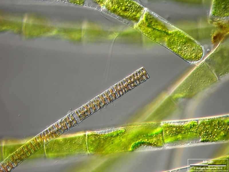
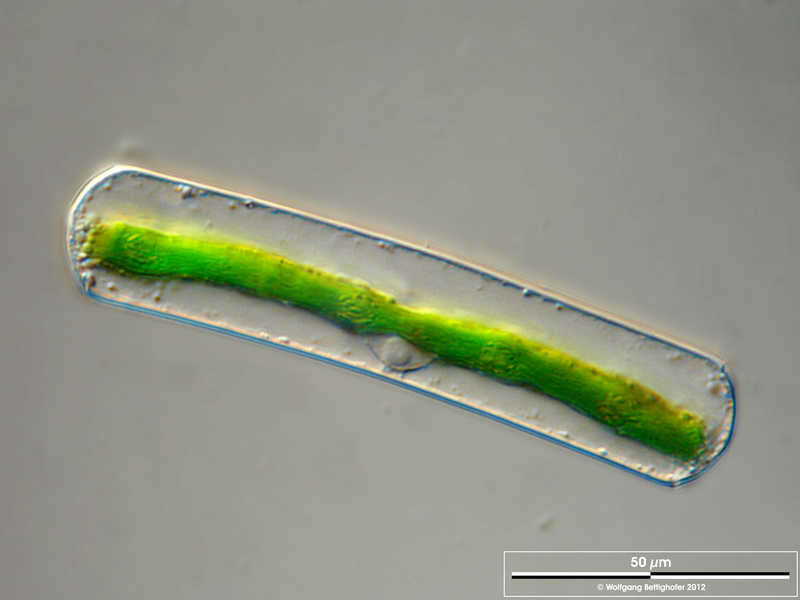
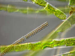
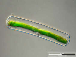
Mougeotia spec. The scale bar indicates 50 µm. Collected from a pond near the Bodden bay Schwarzer Peter in the southern part of the isle Hiddensee (German Baltic Sea). This image was taken using Zeiss Axioplan with Olympus OM-D M5 MKII.Image under Creative Commons License V 3.0 (CC BY-NC-SA). Place name: Pond near the Bodden bay Schwarzer Peter, Hiddensee (German Baltic Sea) Latitude: 54.514946 Longitude: 13.082471 Der Messbalken markiert eine Länge von 50 µm. Probe aus einem Teich nahe der Boddenbucht Schwarzer Peter auf Hiddensee. Mikrotechnik: Zeiss Axioplan, Kamera: Olympus OM-D M5 MKII. Creative Commons License V 3.0 (CC BY-NC-SA). For permission to use of (high-resolution) images please contact postmaster@protisten.de.
-
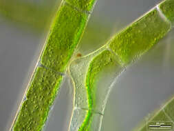
Mougeotia spec. The specimen was gathered in the wetlands of national park Unteres Odertal (100 km north east of Berlin). The image was built up using several photomicrographic frames with manual stacking technique. Images were taken using Zeiss Universal with Olympus C7070 CCD camera. Image under Creative Commons License V 3.0 (CC BY-NC-SA). Place name: Creek in Oder valley 100 km north east of Berlin (Germany) Latitude: 53.135032 Longitude: 14.348738 Die Probe wurde in den Feuchtgebieten des Nationalpark Unteres Odertal (100 km nordöstlich von Berlin) gesammelt. Mikrotechnik: Zeiss Universal, Kamera: Olympus C7070. Creative Commons License V 3.0 (CC BY-NC-SA). For permission to use of (high-resolution) images please contact postmaster@protisten.de.
-
Mougeotia spec. The scale bar indicates 50 µm. Collected from a pond near the Bodden bay Schwarzer Peter in the southern part of the isle Hiddensee (German Baltic Sea). This image was taken using Zeiss Axioplan with Olympus OM-D M5 MKII.Image under Creative Commons License V 3.0 (CC BY-NC-SA). Place name: Pond near the Bodden bay Schwarzer Peter, Hiddensee (German Baltic Sea) Latitude: 54.514946 Longitude: 13.082471 Der Messbalken markiert eine Länge von 50 µm. Probe aus einem Teich nahe der Boddenbucht Schwarzer Peter auf Hiddensee. Mikrotechnik: Zeiss Axioplan, Kamera: Olympus OM-D M5 MKII. Creative Commons License V 3.0 (CC BY-NC-SA). For permission to use of (high-resolution) images please contact postmaster@protisten.de.
-
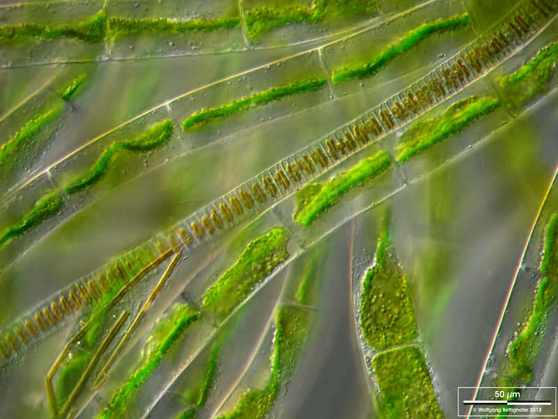
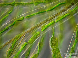
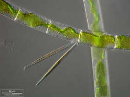
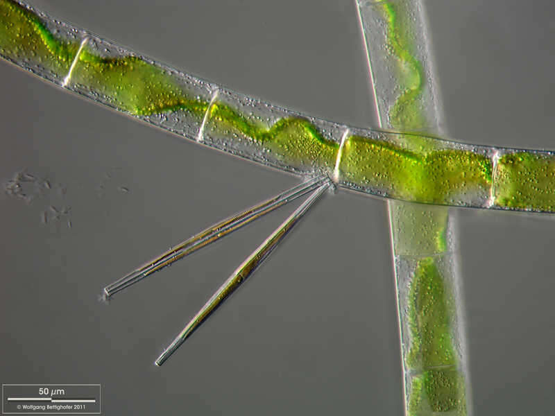
Mougeotia spec. Mougeotia accompanied by the diatom Fragilaria ulna. The scale bar indicates 50 µm. The specimen was gathered in the wetlands of national park Unteres Odertal (100 km north east of Berlin). The image was built up using several photomicrographic frames with manual stacking technique. Images were taken using Zeiss Universal with Olympus C7070 CCD camera.Image under Creative Commons License V 3.0 (CC BY-NC-SA). Place name: Creek in Oder valley 100 km north east of Berlin (Germany) Latitude: 53.135032 Longitude: 14.348738 Mougeotia zusammen mit der Diatomee Fragilaria ulna. Multiebenen-Abbildung, manuell gestapelt. Der Messbalken markiert eine Länge von 10 µm. Die Probe wurde in den Feuchtgebieten des Nationalpark Unteres Odertal (100 km nordöstlich von Berlin) gesammelt. Mikrotechnik: Zeiss Universal, Kamera: Olympus C7070. Creative Commons License V 3.0 (CC BY-NC-SA). For permission to use of (high-resolution) images please contact postmaster@protisten.de.
-
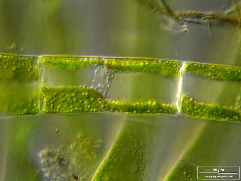
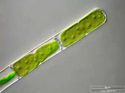
Mougeotia spec. Scale bar indicates 25 µm.The specimen was gathered in the wetlands of national park Unteres Odertal (100 km north east of Berlin). The image was built up using several photomicrographic frames with manual stacking technique. Images were taken using Zeiss Universal with Olympus C7070 CCD camera. Image under Creative Commons License V 3.0 (CC BY-NC-SA). Place name: Creek in Oder valley 100 km north east of Berlin (Germany) Latitude: 53.135032 Longitude: 14.348738 Multiebenen-Abbildung, manuell gestapelt. Der Messbalken markiert eine Länge von 25 µm. Die Probe wurde in den Feuchtgebieten des Nationalpark Unteres Odertal (100 km nordöstlich von Berlin) gesammelt. Mikrotechnik: Zeiss Universal, Kamera: Olympus C7070. Creative Commons License V 3.0 (CC BY-NC-SA). For permission to use of (high-resolution) images please contact postmaster@protisten.de.
-
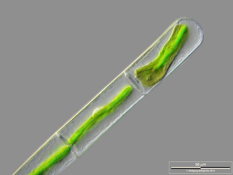
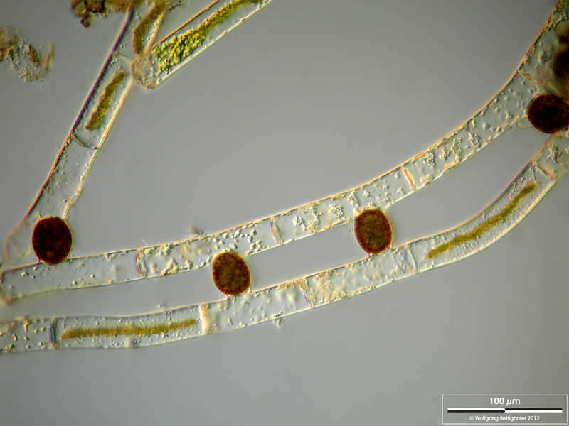
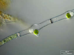
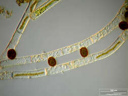
Mougeotia spec. Zygotes after conjugation. Scale bar indicates 100 µm.Sample from a wetland at the Pillersee (Tyrol, Austria). The image was built up using several photomicrographic frames with manual stacking technique. Images were taken using Zeiss Universal with Olympus C7070 CCD camera.Image under Creative Commons License V 3.0 (CC BY-NC-SA). Place name: Wetland at the Pillersee (Tyrol, Austria) Latitude: 47.531785 Longitude: 12.573095 Zygoten nach Konjugation. Multiebenen-Abbildung, manuell gestapelt. Der Messbalken markiert eine Länge von 100 µm. Probe aus einer Feuchtwiese beim Pillersee in Tirol. Mikrotechnik: Zeiss Universal, Kamera: Olympus C7070. Creative Commons License V 3.0 (CC BY-NC-SA). For permission to use of (high-resolution) images please contact postmaster@protisten.de.
-
Mougeotia spec. The scale bar indicates 50 µm. Collected from a pond near the Bodden bay Schwarzer Peter in the southern part of the isle Hiddensee (German Baltic Sea). This image was taken using Zeiss Axioplan with Olympus OM-D M5 MKII.Image under Creative Commons License V 3.0 (CC BY-NC-SA). Place name: Pond near the Bodden bay Schwarzer Peter, Hiddensee (German Baltic Sea) Latitude: 54.514946 Longitude: 13.082471 Der Messbalken markiert eine Länge von 50 µm. Probe aus einem Teich nahe der Boddenbucht Schwarzer Peter auf Hiddensee. Mikrotechnik: Zeiss Axioplan, Kamera: Olympus OM-D M5 MKII. Creative Commons License V 3.0 (CC BY-NC-SA). For permission to use of (high-resolution) images please contact postmaster@protisten.de.
-
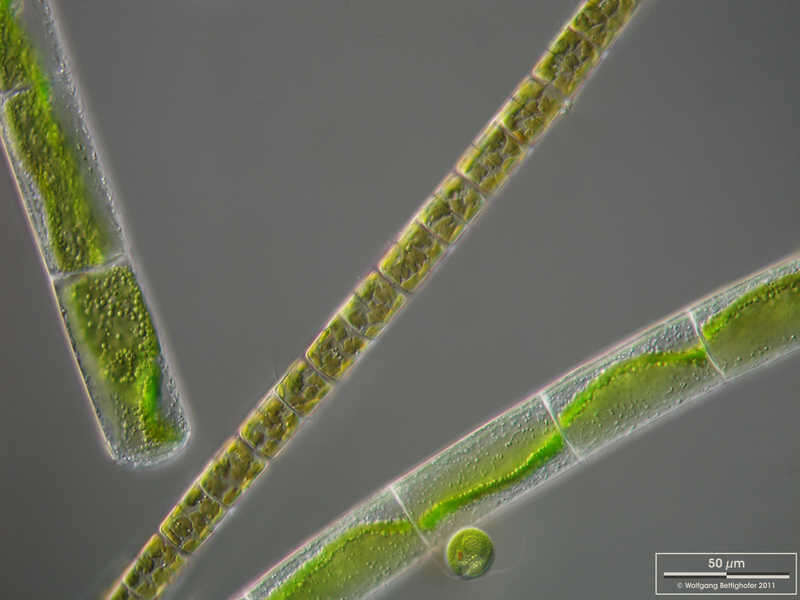
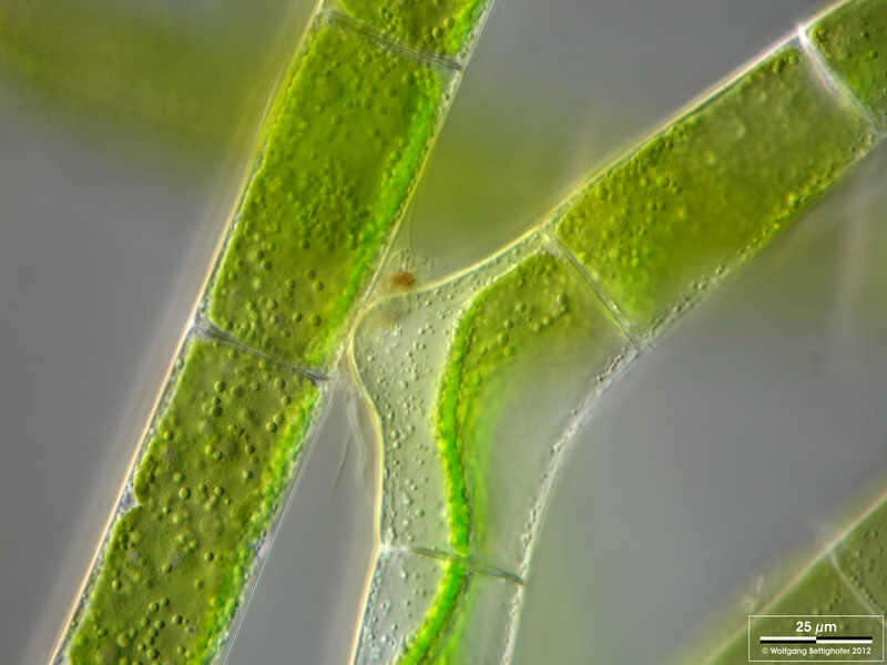
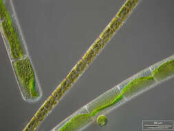
Mougeotia spec. Mougeotia accompanied by the diatom Melosira varians and a flagellated green alga Chlamydomonas. The scale bar indicates 50 µm. The specimen was gathered in the wetlands of national park Unteres Odertal (100 km north east of Berlin). The image was built up using several photomicrographic frames with manual stacking technique. Images were taken using Zeiss Universal with Olympus C7070 CCD camera.Image under Creative Commons License V 3.0 (CC BY-NC-SA). Place name: Creek in Oder valley 100 km north east of Berlin (Germany) Latitude: 53.135032 Longitude: 14.348738 Mougeotia zusammen mit der Diatomee Melosira varians und einer Geißel tragenden Grünalge Chlamydomonas. Multiebenen-Abbildung, manuell gestapelt. Der Messbalken markiert eine Länge von 50 µm. Die Probe wurde in den Feuchtgebieten des Nationalpark Unteres Odertal (100 km nordöstlich von Berlin) gesammelt. Mikrotechnik: Zeiss Universal, Kamera: Olympus C7070. Creative Commons License V 3.0 (CC BY-NC-SA). For permission to use of (high-resolution) images please contact postmaster@protisten.de.